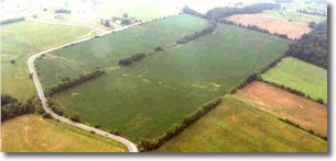
- LOCATION:
- Turtlecreek Township
- West Route 123
- Lebanon, Ohio 45036
The Loeb Memorial Park is located on the west side of State Route 123, 3 miles to the northwest of the city Lebanon, Ohio. The property is bounded by SR 123 to the north and east, agricultural land to the south and west. Turtlecreek Township, where the park is located is presently and projected as a very fast growing Township. The park is next to a planned residential community of 50 new homes and 3 miles from Lebanon, Ohio with a population of approximately 15,000 people. It is 5.5 miles west of I-75.
HISTORY
The property was purchased from the Loeb Foundation on April 21, 2000. The site has no significant historical or archeological features; primarily the site has remained agricultural and has been farmed over the past several years, present back to 1956. The acreage of property is 66.3789, a portion of the late Dr. Justus Loeb farm.
DESCRIPTION
A review of the topographic map shows the property is gently sloping south, the east and west sides are divided. Intermittent tributary of Turtlecreek, a tributary of the Little Miami River. A pipeline right-of-way, 120 feet wide, goes across the northern portion of the property from west to east. The Lebanon airport is located approximately 3,000 feet to the south of the property.
| TOTAL ACREAGE: |
66.3789 acres |
| WOODED ACREAGE: |
Approximately 6 acres |
| FIELDED ACREAGE: |
Approximately 60 acres |
GEOLOGICAL TOPOGRAPHICAL AND GEOGRAPHICAL CHARACTERISTICS
The native soil beneath this property is generally silt loam to an average depth of 3 feet below the round surface. The surface soil has moderately slowed permeability. The surface deposits are underlain by generally glacier till material to an approximate depth of 25 feet; these subsurface deposits are underlain by bedrock. A substantial source of ground water is not likely to exist beneath the property. Topographic map shows the property is gently sloping to the south and the tributary of Turtlecreek running north and south with acreage also sloping east to west to the center of the creek. This tract of land is located in the center portion of Warren County to the west.
PRESENT USE
Agricultural/Being Farmed